Skip to content
TLT Photography
Toggle menu
  • Photography
    • Landscape & Wildlife
    • Client Work
    • 3D Model Gallery
    • Family Archive
  • Adventures
  • Photo Blog
  • Contact

Category: Review

December 15, 2017February 16, 20183D Modeling, Data Solutions, GIS Solutions, Photogrammetry, Review

Planimetrics

This past week I have been rushing to complete curb, edge of pavement and sidewalk feature extraction for Avisight.  This was really […]

Share this:

  • Click to email a link to a friend (Opens in new window)
  • Click to share on LinkedIn (Opens in new window)
  • Click to share on Facebook (Opens in new window)
  • Click to share on Twitter (Opens in new window)
  • Click to share on Pinterest (Opens in new window)
  • Click to share on Pocket (Opens in new window)
  • Click to share on Reddit (Opens in new window)
December 3, 2017February 7, 20183D Modeling, Data Solutions, Photogrammetry, Review

Gold Mine Photogrammetry and LiDAR Work

For the past week or so I have been doing some work for Avisight out of Las Vegas, NV.  The company has […]

Share this:

  • Click to email a link to a friend (Opens in new window)
  • Click to share on LinkedIn (Opens in new window)
  • Click to share on Facebook (Opens in new window)
  • Click to share on Twitter (Opens in new window)
  • Click to share on Pinterest (Opens in new window)
  • Click to share on Pocket (Opens in new window)
  • Click to share on Reddit (Opens in new window)
November 28, 2017February 3, 2018Data Solutions, GIS Solutions, Photogrammetry, Review

Eagle Creek Satellite Imagery Work for SAR

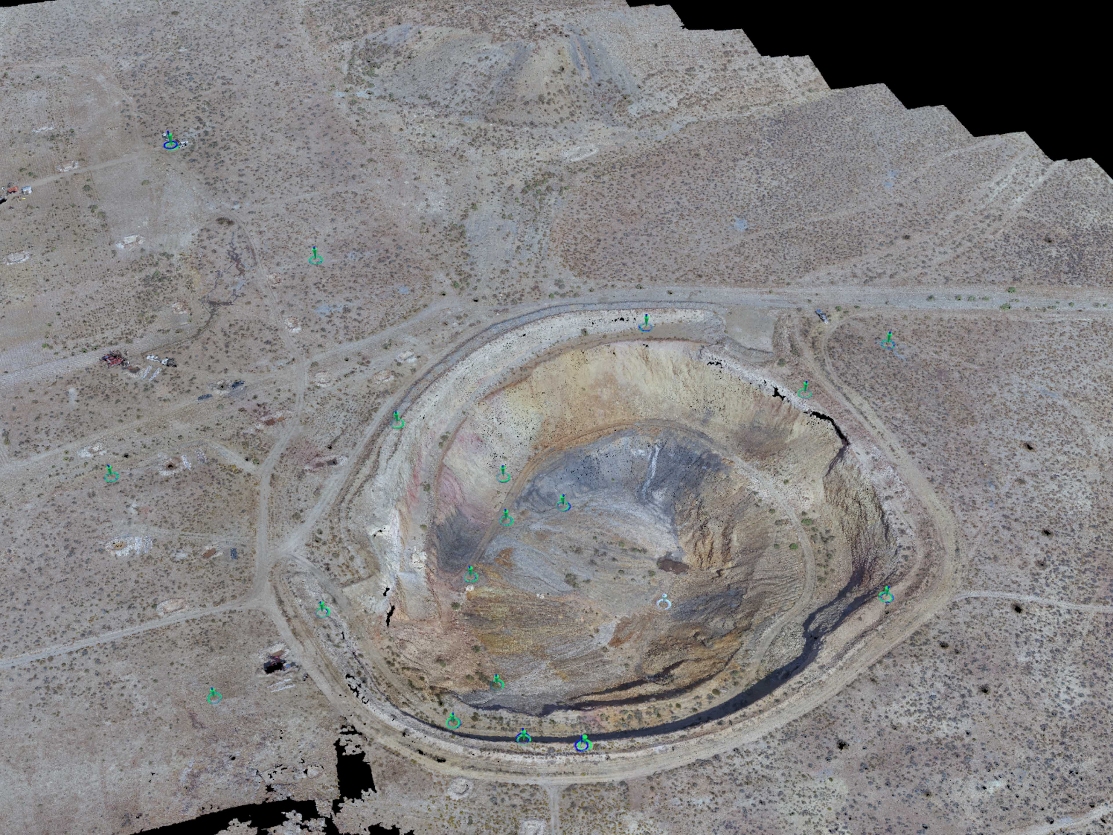
This week I completed a long FREE project to help provide The Multnomah County Sheriff’s Department and local Search And Rescue better […]

Share this:

  • Click to email a link to a friend (Opens in new window)
  • Click to share on LinkedIn (Opens in new window)
  • Click to share on Facebook (Opens in new window)
  • Click to share on Twitter (Opens in new window)
  • Click to share on Pinterest (Opens in new window)
  • Click to share on Pocket (Opens in new window)
  • Click to share on Reddit (Opens in new window)
September 25, 20173D Modeling, Aerial Services, Data Solutions, GIS Solutions, Photogrammetry, Review

Survey-Grade Right of Way Surface Modeling with UAS

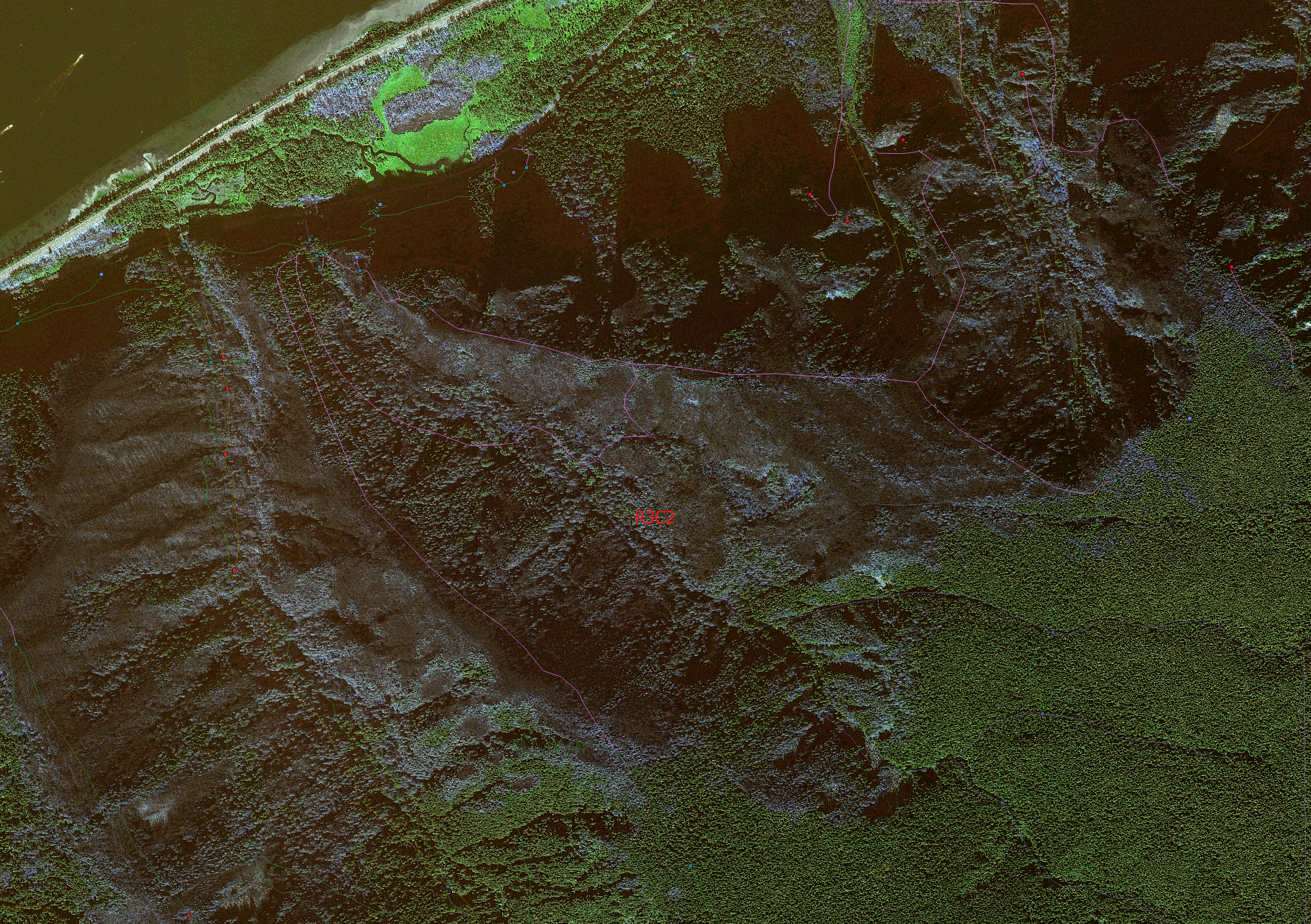
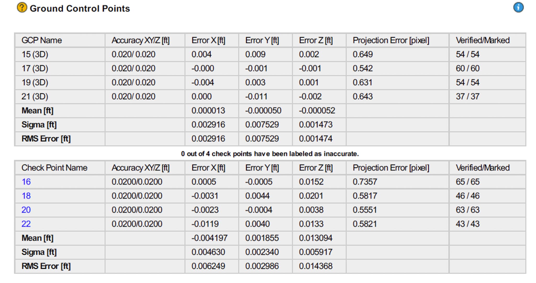
Throughout this summer I have been working with several survey partners to develop a new methodology for cost-effective and accurate right of […]

Share this:

  • Click to email a link to a friend (Opens in new window)
  • Click to share on LinkedIn (Opens in new window)
  • Click to share on Facebook (Opens in new window)
  • Click to share on Twitter (Opens in new window)
  • Click to share on Pinterest (Opens in new window)
  • Click to share on Pocket (Opens in new window)
  • Click to share on Reddit (Opens in new window)
September 22, 2017September 29, 20173D Modeling, Data Solutions, GIS Solutions, Photogrammetry, Review

139th Street Vancouver Testing Site

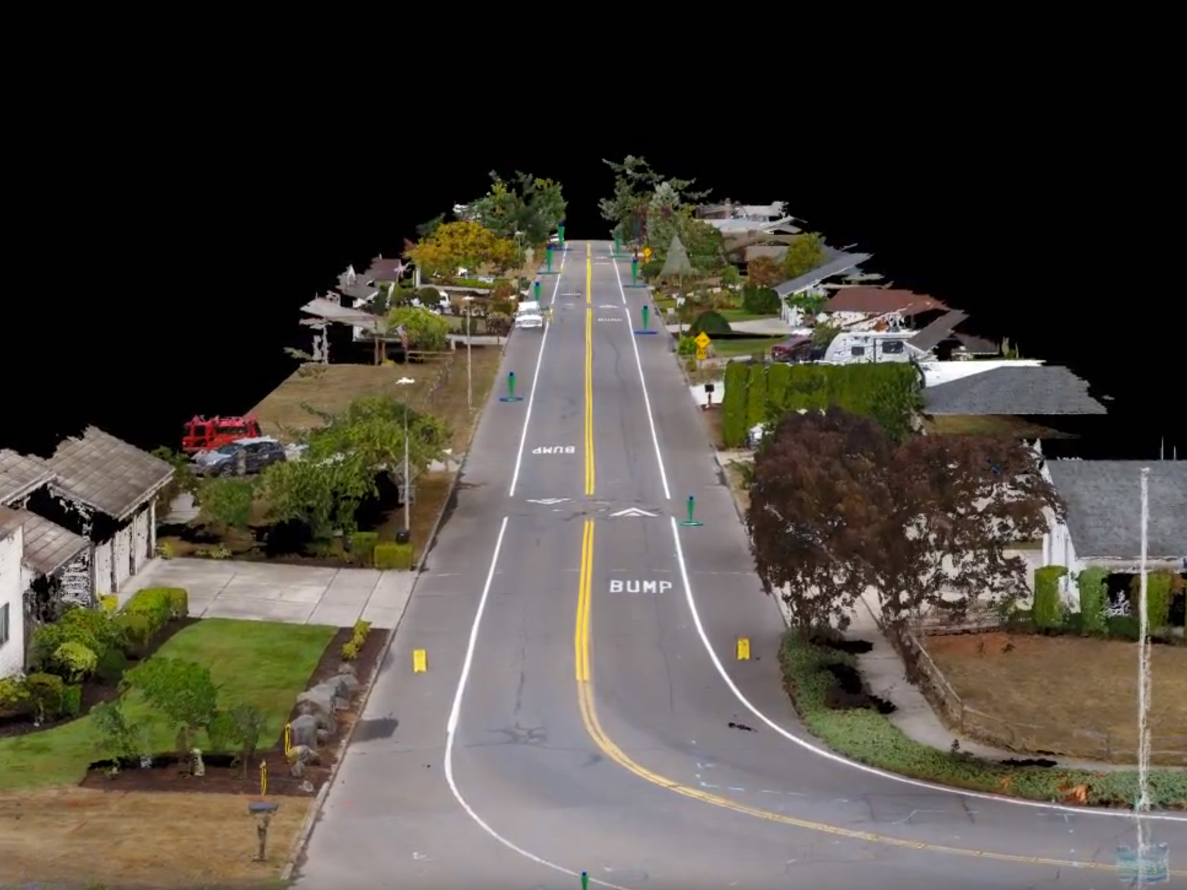
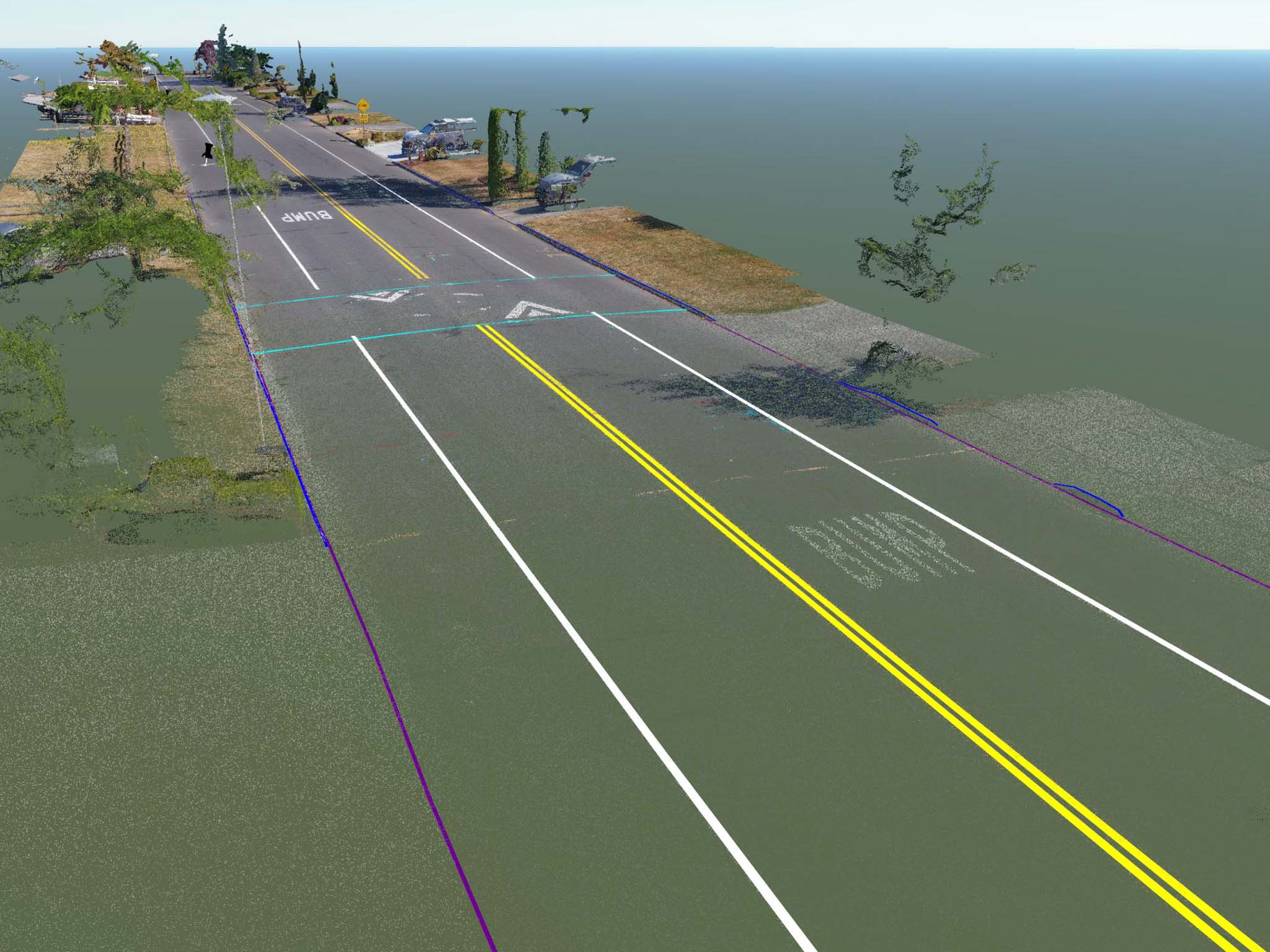
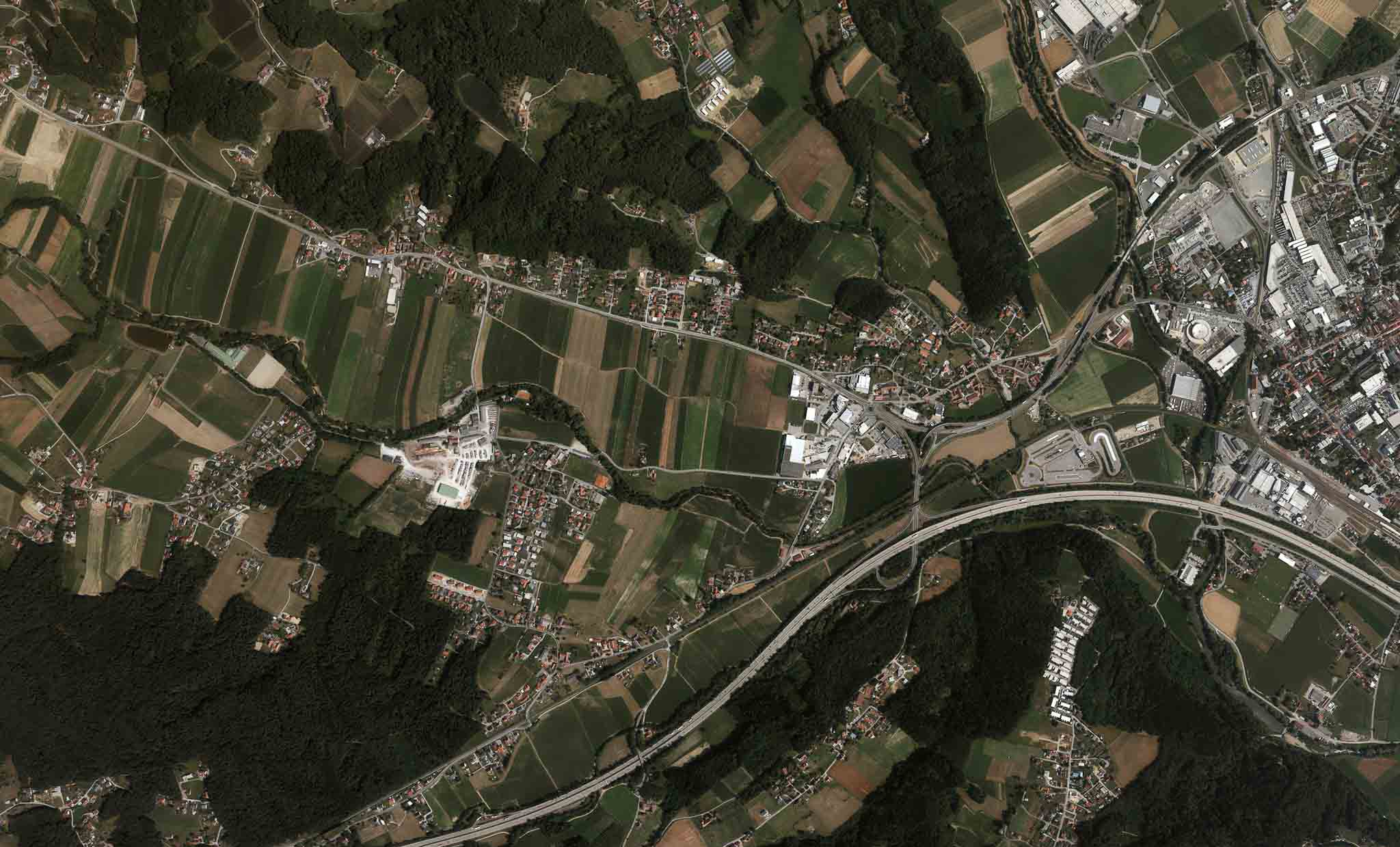
139th Street in Vancouver, WA is serving as a testing ground for comparing ground models I create with modern photogrammetry and structure […]

Share this:

  • Click to email a link to a friend (Opens in new window)
  • Click to share on LinkedIn (Opens in new window)
  • Click to share on Facebook (Opens in new window)
  • Click to share on Twitter (Opens in new window)
  • Click to share on Pinterest (Opens in new window)
  • Click to share on Pocket (Opens in new window)
  • Click to share on Reddit (Opens in new window)
August 3, 2017September 25, 20173D Modeling, Aerial Services, Data Solutions, GIS Solutions, Inspections, Photogrammetry, Review

Overcoming a Communication Hurdle and Achieving Groundbreaking Results

I have been working with my trused partners at BD Aerial developing a UAS survey program for construction sites. We have been […]

Share this:

  • Click to email a link to a friend (Opens in new window)
  • Click to share on LinkedIn (Opens in new window)
  • Click to share on Facebook (Opens in new window)
  • Click to share on Twitter (Opens in new window)
  • Click to share on Pinterest (Opens in new window)
  • Click to share on Pocket (Opens in new window)
  • Click to share on Reddit (Opens in new window)
July 13, 2017September 27, 20173D Modeling, Action Sports, Aerial Services, Data Solutions, GIS Solutions, Inspections, Marketing, Personal Photographer, Photogrammetry, Real Estate, Review

TLT Photography Acquires DJI Phantom 4 Pro Platform

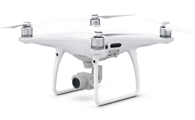
TLT Photography has chosen the DJI Phantom 4 Pro platform as it’s official platform for aerial acquisition. This platform is equipped with […]

Share this:

  • Click to email a link to a friend (Opens in new window)
  • Click to share on LinkedIn (Opens in new window)
  • Click to share on Facebook (Opens in new window)
  • Click to share on Twitter (Opens in new window)
  • Click to share on Pinterest (Opens in new window)
  • Click to share on Pocket (Opens in new window)
  • Click to share on Reddit (Opens in new window)
June 21, 2017Data Solutions, Photogrammetry, Review

Understanding Spatial Resolution with Drones

“We can get 1cm with our drone!” Have you heard someone in the drone industry say something similar to this? I have, […]

Share this:

  • Click to email a link to a friend (Opens in new window)
  • Click to share on LinkedIn (Opens in new window)
  • Click to share on Facebook (Opens in new window)
  • Click to share on Twitter (Opens in new window)
  • Click to share on Pinterest (Opens in new window)
  • Click to share on Pocket (Opens in new window)
  • Click to share on Reddit (Opens in new window)
TLT-Photography Logo
January 1, 2017April 6, 20173D Modeling, Action Sports, Adventure, Aerial Services, Data Solutions, Digital Archiving, GIS Solutions, Guide Services, Inspections, Itineraries & Planning, Marketing, Nature Photography, Personal Photographer, Photogrammetry, Photography, Real Estate, Review, Special Events

Site Branding!

Today the site logo was completed. I haven’t got the exact finished version yet but it will look nearly identical to this. […]

Share this:

  • Click to email a link to a friend (Opens in new window)
  • Click to share on LinkedIn (Opens in new window)
  • Click to share on Facebook (Opens in new window)
  • Click to share on Twitter (Opens in new window)
  • Click to share on Pinterest (Opens in new window)
  • Click to share on Pocket (Opens in new window)
  • Click to share on Reddit (Opens in new window)

Recent Posts

  • Baja Mexico Film
  • North Bethany Ridge Aerials
  • Tillamook Head Lighthouse
  • Boones Ferry Road
  • Wilsonville Road

Recent Comments

  • Homepage on Data Solutions
  • Anonymous on Tillamook Head Lighthouse
  • Holden Greene on Protected: Large Traditional Aerial Mapping Project in Southwest
  • Anonymous on Protected: Large Traditional Aerial Mapping Project in Southwest
  • Cost Effective Photography Salt Lake City Utah Area Payment Option | Salt Lake City Photography Guy on Cost-Effective Aerial Mapping by Helicopter

Archives

  • January 2020
  • October 2018
  • September 2018
  • August 2018
  • July 2018
  • June 2018
  • May 2018
  • April 2018
  • March 2018
  • February 2018
  • January 2018
  • December 2017
  • November 2017
  • October 2017
  • September 2017
  • August 2017
  • July 2017
  • June 2017
  • May 2017
  • April 2017
  • March 2017
  • January 2017
  • November 2016
  • December 2011

Categories

  • 3D Modeling
  • Action Sports
  • Adventure
  • Aerial Services
  • Data Solutions
  • Digital Archiving
  • GIS Solutions
  • Guide Services
  • Inspections
  • Itineraries & Planning
  • Marketing
  • Nature Photography
  • Personal Photographer
  • Photogrammetry
  • Photography
  • Real Estate
  • Review
  • Special Events
  • Survey

Meta

  • Log in
  • Entries feed
  • Comments feed
  • WordPress.org
© 2025 TLT Photography. Proudly powered by Sydney
 

Loading Comments...