Skip to content
TLT Photography
Toggle menu
  • Photography
    • Landscape & Wildlife
    • Client Work
    • 3D Model Gallery
    • Family Archive
  • Adventures
  • Photo Blog
  • Contact

Month: March 2017

March 28, 2017June 22, 20173D Modeling, Aerial Services, Data Solutions, Photogrammetry

New 3D modeling Services

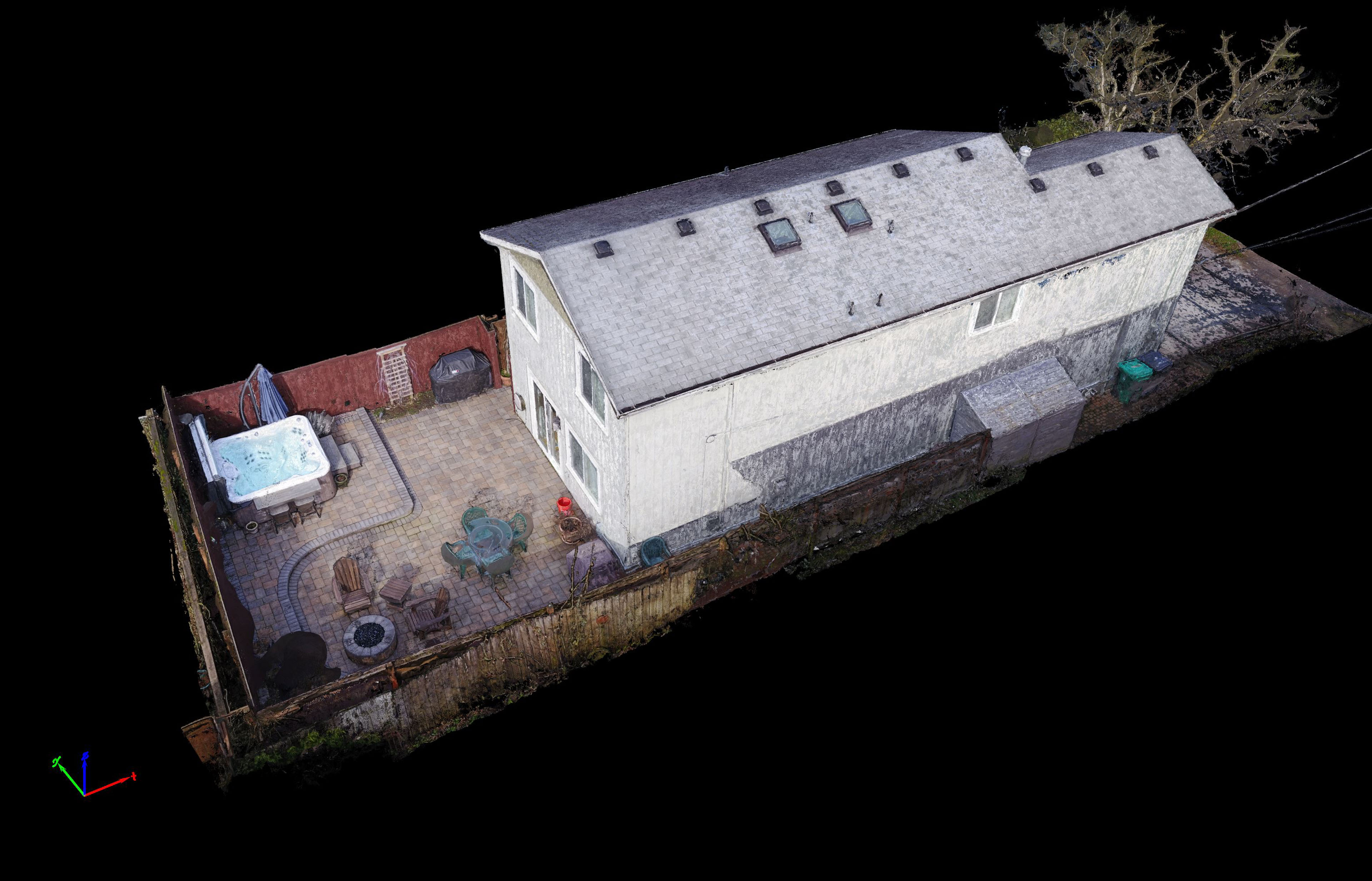
TLT Photography is pleased to announce new 3D modeling services. Using advanced photogrammetric software and knowledge gained over a decade of experience […]

Share this:

  • Click to email a link to a friend (Opens in new window)
  • Click to share on LinkedIn (Opens in new window)
  • Click to share on Facebook (Opens in new window)
  • Click to share on Twitter (Opens in new window)
  • Click to share on Pinterest (Opens in new window)
  • Click to share on Pocket (Opens in new window)
  • Click to share on Reddit (Opens in new window)
Chenoweth Cliffs 3D Terrain Model
March 24, 2017April 6, 20173D Modeling, Aerial Services, Data Solutions, Inspections, Photogrammetry

3D Terrain Visualization From UAV (Drones)

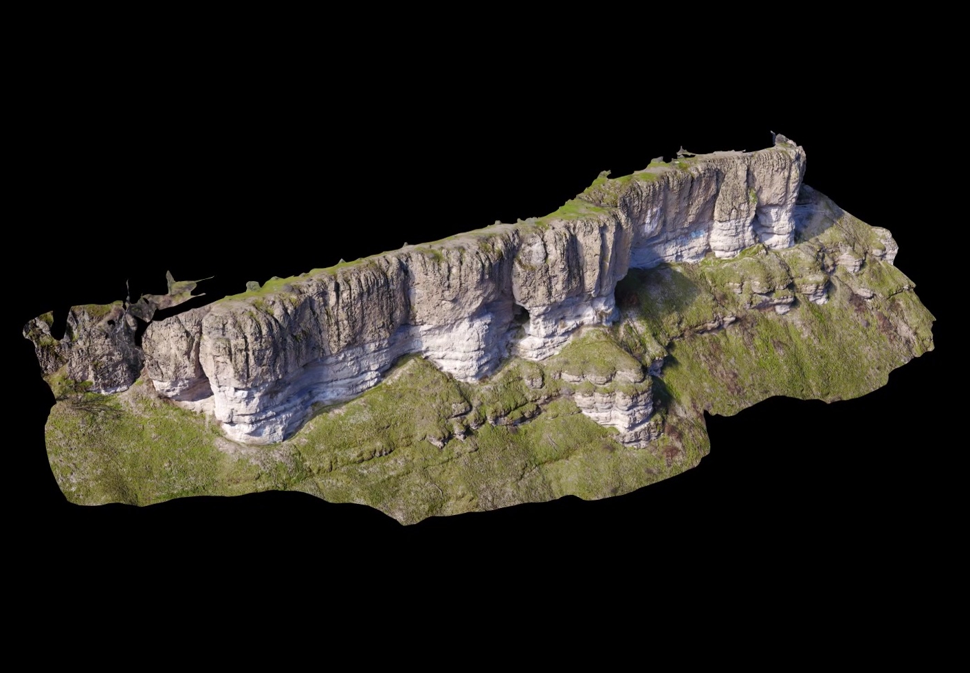
Ultra high-resolution 3D terrain models produced by modern photogrammetric software from aerial imagery captured by UAV is nothing short of stunning. No […]

Share this:

  • Click to email a link to a friend (Opens in new window)
  • Click to share on LinkedIn (Opens in new window)
  • Click to share on Facebook (Opens in new window)
  • Click to share on Twitter (Opens in new window)
  • Click to share on Pinterest (Opens in new window)
  • Click to share on Pocket (Opens in new window)
  • Click to share on Reddit (Opens in new window)
March 16, 2017April 6, 2017Action Sports, Aerial Services

3rd Party Software Lesson Learned

One of the most sought after features from DJI is the ability to track objects while also changing altitudes.  For safety reasons […]

Share this:

  • Click to email a link to a friend (Opens in new window)
  • Click to share on LinkedIn (Opens in new window)
  • Click to share on Facebook (Opens in new window)
  • Click to share on Twitter (Opens in new window)
  • Click to share on Pinterest (Opens in new window)
  • Click to share on Pocket (Opens in new window)
  • Click to share on Reddit (Opens in new window)

Recent Posts

  • Baja Mexico Film
  • North Bethany Ridge Aerials
  • Tillamook Head Lighthouse
  • Boones Ferry Road
  • Wilsonville Road

Recent Comments

  • Homepage on Data Solutions
  • Anonymous on Tillamook Head Lighthouse
  • Holden Greene on Protected: Large Traditional Aerial Mapping Project in Southwest
  • Anonymous on Protected: Large Traditional Aerial Mapping Project in Southwest
  • Cost Effective Photography Salt Lake City Utah Area Payment Option | Salt Lake City Photography Guy on Cost-Effective Aerial Mapping by Helicopter

Archives

  • January 2020
  • October 2018
  • September 2018
  • August 2018
  • July 2018
  • June 2018
  • May 2018
  • April 2018
  • March 2018
  • February 2018
  • January 2018
  • December 2017
  • November 2017
  • October 2017
  • September 2017
  • August 2017
  • July 2017
  • June 2017
  • May 2017
  • April 2017
  • March 2017
  • January 2017
  • November 2016
  • December 2011

Categories

  • 3D Modeling
  • Action Sports
  • Adventure
  • Aerial Services
  • Data Solutions
  • Digital Archiving
  • GIS Solutions
  • Guide Services
  • Inspections
  • Itineraries & Planning
  • Marketing
  • Nature Photography
  • Personal Photographer
  • Photogrammetry
  • Photography
  • Real Estate
  • Review
  • Special Events
  • Survey

Meta

  • Log in
  • Entries feed
  • Comments feed
  • WordPress.org
© 2025 TLT Photography. Proudly powered by Sydney