
I have been working with my trused partners at BD Aerial developing a UAS survey program for construction sites. We have been working for several large nationwide construction firms since spring and have learned a lot in the pogress. Because of an NDA in place with BD Aerial I can’t go into details about what exactly we are modeling but I can say that it is ultra high-resolution 3D reality capture for BIM. Basically, we are flying a site at around 60-80 feet in the air and creating highly detailed 3D models of the site with the sub-cm resolution imagery. Thus far our clients have been very impressed by what we have produced for them. The end goal is for them to be able to compare what was actually built with what they have in their design files.
A big challenge for me as a Certified Photogrammetrist and Mapping Scientist in Remote Sensing is overcoming the communication gap between myself in the geospatial world and our clients from the design and architectural world. My world is based on geodetics, cartography, and known coordinate reference systems in a GIS environment. Their world is based on grid systems, and local measurements in the CAD design world. I’ve spent the past 10 years of my life working with known coordinate systems. Each has their own identifiable “EPSG” Code which details all the geodetic information needed to place subject matter in the right spot on earth. When I began to ask our construction clients for the coordinate system (epsg code) they work in all we got were shrugs and confusion.
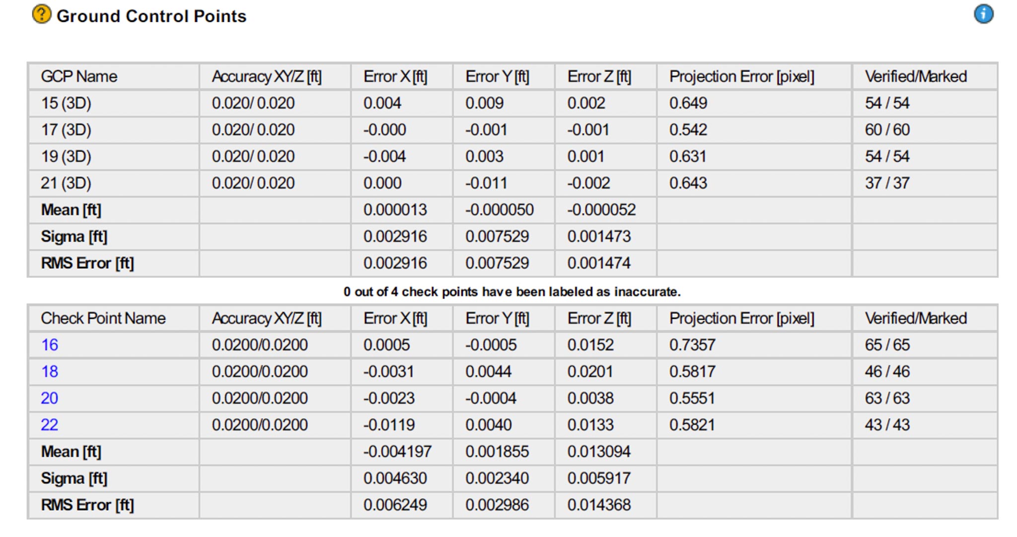
It became apparent that I would need to find a way to process the data in a local grid coordinate system specific to each job site. Once I figured out how to do this using air target control shot by a total station on site and provided to me in the site’s local coordinate grid system I thought we were good to go until I looked at the accuracy report and thought I had done something wrong… it seemed too good to be true. But, I then realized that because I was in a local grid coordinate system I had eliminated all possible error associated with GPS that I’m used to with survey points in earth-projected coordinate systems. I’ve known that with clear, crisp images a data scientist can measure with an accuracy of anywhere from 1/5 to 1/10 the pixel size. In this case the pixel size was 4.5mm because we acquired the data at 60 feet. The image attached to this post shows that Used 4 points for direct georeferencing of my dataset but then set aside 4 other points, not used in georeferencing to serve as unbiased checkpoints for the relative accuracy assessment. We achieved a relative site-specific accuracy of 1.9mm in X, 0.9mm in Y and 4mm in Z. This is simpoly astounding and definitely comparable to any laser system out there.