
Full Story with Links & Photos Here
For the long Memorial Day weekend Emily and I decided to take Leo on a road trip. This is a tough time of year as the snow is too deep for any serious mountain backpacking and anything else we could have decided up on we wouldn’t have been able to bring Leo. So, on a whim we headed north towards Bellingham, WA with the intention of driving down through Whidbey Island and then around the Olympic Peninsula which Emily hadn’t seen yet. We had no concrete places to sleep and no clear itinerary yet it turned out to be a blast!
We left late morning on Saturday and made it to Vernon, WA around 2:30pm for a tasty lunch at the Trumpeter Restaurant on the bank of the Skagit River in town. Just north of there we left I-5 onto backroads to Larrabee State Park where we planned to spend the afternoon exploring. We had bought a Washington Discovery Pass on the drive up I-5 so we were able to enter all our planned parks in Washington without paying the fee. It had been a long drive so we first walked down to the rocky shore of the park to look out over the northern Puget Sound towards Vancouver Island and the San Juan group of islands.
It was a beautiful afternoon with a bunch of kayakers out on the calm water and freighter ships in the far distance with the Olympic Mountains behind them. Leo thoroughly enjoyed sitting on the rocks with us in the sunshine. We watched seabirds and several flocks of geese fly over the water in front of us and I took some time to explore some small tide pools and flowers around the area with my camera. Emily hung out with Leo and made sure he didn’t try to drink the seawater as sometimes he attempts to..
We had walked through a colorfully painted tunnel under some train lines and I had read from numerous reviewers that the park was a nightmare to camp in due to the rumbling noise all night of the trains. So, we decided we needed to search elsewhere but before we left we drove up the windy Chuckanut dirt drive to the Cyrus Gates Overlook at the top of the park which overlooked the sound. Trees had become a bit overgrown at the viewpoint blocking some of the view but we could still get a few pics out over the Sound and all the islands it contains.
On the way back down the drive we pulled over at a viewpoint I noticed that was pointing northeastward towards Mt. Baker. I was able to get some great panorama shots of the huge glaciated peak in the distance as well as a couple good ones of Leo with the sun shinning through the trees behind him. From there it was a short drive down the road, and out of the park to the wonderful town of Fairhaven just south of Bellingham, WA
In Fairhaven we stopped at a liquor store for some whiskey and to fill up a growler we had tossed in the Prius. We also stopped at a Whole Foods to grab an odd mixture of soup, sushi, and salad for dinner which we took down to the Boulevard Park on the shore to eat and watch the sunset over the Puget Sound. There were a lot of other people at the park with us and I wondered if there was going to be some sort of fireworks display but I think it was just the fact that it was wonderful spring weather and a holiday weekend!
I took a gamble and headed us back onto I-5 to Alger, WA where took a backroad into the eastern entrance of Larrabee State Park looking for a campsite. We found a perfect place with no one around at the Blanchard Mountain Trail Lower Parking Lot just outside the boundary of the park. Perfectly legal but not perfectly quiet as we went to bed with the sounds of redneck locals revving their quad engines well into 1am in the morning….
In the morning we got up very early and headed into the park to the Samish Bay Overlook where we had crisp views of the Olympics in the distance and great views over the Puget Sound. Being early at 7am we had no problem finding a parking spot and were on the Pacific Northwest Trail (PNT) towards Oyster Dome by 7:45am in perfect temps for hiking. It was a short out-and-back trail of about 4 miles which was perfect for Leo.
We made it to the lookout in just over an hour where we stopped for some snacks and to check out the views over the Sound. The actual summit of Oyster Dome was just a few hundred feet away so we of course ran over to it on the way out to tap the top with our feet (and paws). On our way out it was amazing to see the number of people now coming in along the trail. I’m not exaggerating when I say well over a hundred, and most had dogs with them which I thought was terrific. When we got back to the parking lot it was full with cars waiting for people like us to leave. As we drove out cars were lining the roadside for a good quarter mile and it was only 10am! Yikes! Time to leave the park!
We headed out of the park back onto I5 for a short ways then to Anacortes which is where the ferries leave for the San Juan Islands. It was too late in the day to even think we would be able to catch a ferry without a 3 hour wait so we instead chose to check out the old downtown of this small town and grab a delicious breakfast at the Calico Cupboard where were given a huge cinnamon bun to start off with! Honestly, I’ve lived and traveled to a lot of places on earth but the food in the Pacific Northwest, no matter how small a town is absolutely out of this world!
Before leaving town we drove a short distance to the very small Cape Sante Park which had amazing views over the small town and east towards Mt. Baker as well as the Northern Cascades of Washington. There was a huge oil ship out in the bay as well as a very cool looking tug called the Crowley Protector. Leo was the hit of the park as usual as a family with kids couldn’t get enough of him.
On our way out of Anacortes Emily spotted something super cool that I had totally missed while driving. She said, “hey I just saw a giant old overgrown ship!” Hmmm. I swung the car around and headed back down the road to a pullout above a small marina. Sure enough, there was a giant wooden vessel that appeared to be protecting the marina. A little google search revealed that it was the schooner La Merced which was left here to die and serve as a breakwater for the marina. Very unique, and very Pacific Northwest. We also got to watch the Anacortes ferry heading out into the fog towards the San Juan Islands before hitting the road again towards Deception Pass.
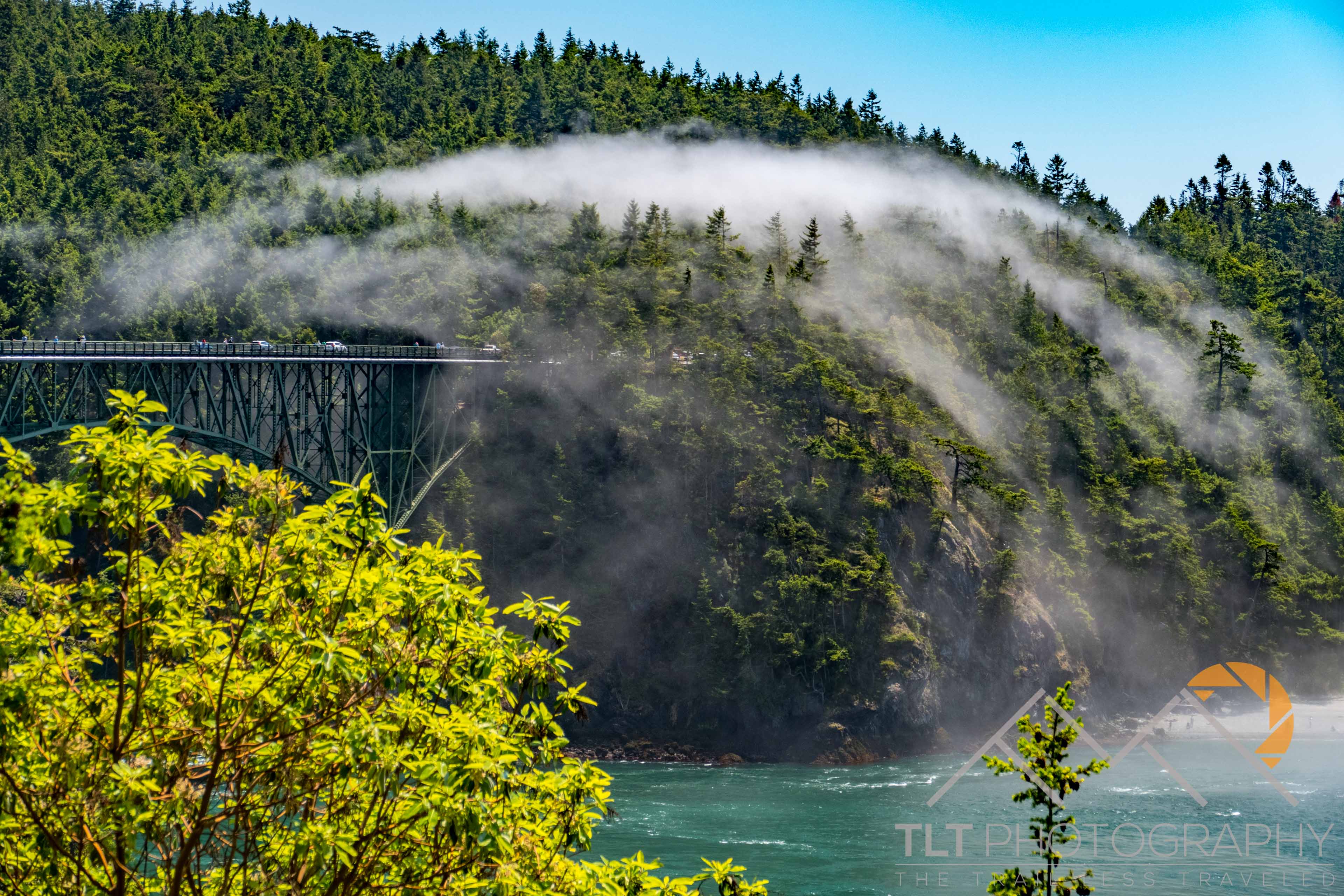
Just before Deception Pass we pulled over the side of the extremely busy road to get a time-lapse of the fog rolling over the Deception Pass bridge. I had heard stories about the cool weather and fog in this area as well as the crazy current through this narrow passage but it they don’t do the place justice. The tidewater pouring through the passage looked just like a deep wide river like the Rogue at high flow. I can’t believe anyone could sea kayak around this area! We drove over the bridge slowly with the rest of the traffic and were lucky enough to find a spot to park at the southern end so we could walk out on the bridge with Leo for some more shots towards the foggy Sound.
Before continuing on I convinced Emily to hike up Goose Rock Summit, a small point of land at Deception Pass State Park despite us both being in flip flops. It was only 3.3 miles round trip and we got some cool views of the underside of the bridge as well as out over the Puget Sound and towards the Olympics. The shore of Whidbey Island which we had just crossed onto stretched out to the south of us and there were only a few remnants of fog out over the sound as we headed back to the car.
We drove down the hillside and lucked out with a parking spot at the beach below the bridge. I grabbed the growler we had filled up the night before and kept cool in the shade of the trunk and we headed down to the beach with our camp chairs to relax. I may have mentioned this before I oddly seem to attract the attention of young kids. Emily can back me up on this one. For some reason I fascinate them and they always want to chat with me. Perhaps it is because I talk to them like adults without any hint of a “baby voice” and I love to give them on-the-spot challenges.
In this case I was approached by a young boy who showed me a rock asking me to take a photo of it (because I had my camera out). I said “no” to his surprise. Then I said, “I’ll take a photo when you make me a rainbow of rocks” = the challenge. For the next 20 minutes he was dead set on finding me a rock for each color of the rainbow. Hence the very “earned” photo posted here 🙂
Leo, Em and I then spent the next several hours reading under the sun and watching the amazing tide rip through the channel bringing boats of all varieties through at crazy speed. A steady stream of cars continued over the bridge above us and there were plenty of people on the beach for the beautiful day. Just before we were going to leave I heard a familiar sound and noticed a Mavic flying above everyone.
I politely walked over to the guy on our way out after he had been flying over everyones heads that he may be breaking the rules flying there in a State Park in Washington over everyone’s heads and to just be careful. I didn’t reprimand, I just told him as a fellow pilot that he might be breaking the rules and could get fined or in trouble. He thanked me and we continued on. I probably wouldn’t have said anything if it wasn’t for the fact of all the people he was flying over, half of which thought it was cool, the other half annoying. Just doing my part to help stop people from giving drone pilots a bad rep.
We continued on south down Whidbey Island to Ebey State Park where I pulled into the entrance station to ask about how to get to the beach as well as if they could suggest anywhere on the island for us to pull over and car camp. To our shock the man responded that a camp site had suddenly opened up because the people never showed up for it the day before and according to the rules after 24hrs of no-show it was a up for grabs! So, Emily and I ended up with the walk-in campsite #11, complete with picnic table, fire pit, and flat tent site just a 60 second walk down a short path from our car! We set up camp and headed into the small town of Coupeville for a wonderful meal and pints at the busy bar of Toby’s Tavern.
When we got back to Ebey we had just enough time to grab the vodka and ginger, camp chairs and camera and head out to the old gun bunker of the park to sit on top of it and watch the sun set into the west over the Puget Sound. There was a paraglider practicing his skills in the steady wind blowing onto us off the Puget Sound. The mainland temps were in the high eighties but we were slightly chilled in our puffy jackets in 50 degree temps and wind at the park. It’s temperature difference between the Island and the mainland is pretty nuts!
We enjoyed our drinks and the beautiful views for about an hour until the chill and the growing darkness urged us to pack up and head back to camp. Before leaving Emily got the bug to check out the bunker which confused the heck out of Leo who suddenly realized that Emily was now underneath him looking out at him from the ground! That night we had a relaxing evening at camp with a fire, more drinks and a tired Leo who found his way into the tent for the night before we even did!
At dinner the night before Emily had suggested we look up ferry reservations which was a good thing. Everything was completely booked to get off the Island except for a 7:15am ferry out of Coupeville towards Townsend, WA and the Olympics. We quickly made a reservation which meant we had to get up at 6am to pack up camp and rush to the ferry terminal. Thankfully, all worked out and we easily made it to the front of the line of cars waiting for the first ferry in the morning.
While Emily slept in the car with Leo I headed up with my camera gear to the front of the Ferry for some time-lapse and wide-angle shots. I was completely alone at the front of the ship. To my complete shock Shannon and Martin suddenly walked out the door and met up with me. Figures that our friends would be the only other crazy people to come out to the front of the ferry in the crisp morning air for the views. We caught up a bit and when the ferry reached Townsend we joined them for coffee and pastries at the “Better Living Through Coffee” shop in town they liked. Apparently they had bought farmland on Whidbey Island I offered it as a place for us to camp next time we wanted to visit the island! Pretty sweet!
After breakfast we headed over to Fort Worden State Park just outside of town to take Leo for a morning walk and to check out the 3in anti-aircraft gun emplacements that were installed in 1920. The guns were now gone but lots of informative signs told us about the impressive defense capabilities of the fort. As we walked around exploring we saw several deer and Leo had a blast chasing us from below as we ran along the top of the fort which he couldn’t get up to because it required scaling metal ladders!
The trail brought us around all the bunkers and we took the time to explore walking through a couple of them before reaching a viewpoint out towards the quaint Point Wilson Lighthouse. The yellow bushes in from of it are the invasive weed Scotch Broom which Emily has learned to hate as it appears everywhere along the roadsides of Washington and Oregon and is spreading quickly. This was also our last great view out towards the Puget Sound before heading further inland around the Olympic Peninsula.
Our first stop was the drive up Hurricane Ridge in the Olympic National Park. We purchased a year Parks Pass for $89 on the way in as we plan to head back here for the Fourth of July and Yosemite was coming up for Emily’s birthday in a couple weeks. The drive up the viewpoint was beautiful with plenty of snowy peaks in the distance. When we got to the lookout I immediately spotted a whistling marmot on the hillside. We had to keep Leo on a leash as dogs aren’t allowed to wander around in a National Park or go on any hiking trails so we were a bit limited in our visit with him with us and it was too hot to leave him in the car.
In the distance over some deer on the hillside in front of us we could see the bulk of the Olympic Mountains with the glaciated Mount Olympus right in the middle of them all. It is a 45 mile ascent that I would like to try later this summer if I can find someone crazy enough to do it with me. We snapped some photos of the views and the wildlife before heading back down the road to continue our long drive around the Peninsula. There were other viewpoints to stop at but we had a long day of driving ahead so instead passed them by.
I had forgotten that route 101 around the Peninsula is actually pretty far outside the bulk of the National Park. It’s a long drive around some pretty cool lakes but for the most part it is just really remote through a lot of forested and mangled landscape from logging. I understand that it provides jobs and is necessary for our economy, etc etc, but it doesn’t mean it is easy to see. When we finally made it to the first of the accessible beaches by car along the Northern Olympic Coast we were ready to get out of the car and have a short walk to stretch our legs.
Cedar Creek Beach was very pretty and very popular. There were very cool sea stacks just off the beach that would have been accessible had it not been for high tide while we were there. Some even had a windows pounded out of them by the strong Pacific waves. There were piles of huge driftwood everywhere and a lighthouse far in the distance on Destruction Island just off the coast.
We spent about an hour walking around the small tide pools with Leo to stretch our legs before the long drive home. Leo was more than happy to race up and down the beach for my camera. Although still in the National Park everyone had their dog off leash on the open beach and we even saw some people having campfires further down the beach behind some rocks which I thought was questionable but probably still legal.
It was a long drive home through much more scarred logging landscape out of the Olympic Peninsula. When we got to the incredibly depressed-looking town of Aberdeen, WA we stopped at the Breakwater Seafood and Chowder restaurant at the mouth of the Wishkah River entering the Chehalis River for a yummy dinner of chowder and bay shrimp salad. This town was one of the most depressing places I have driven through in a while. Home to Kurt Cobain it is no wonder he was depressed. We arrived home around 8pm after a wonderful experience touring the coast of Washington and it’s islands with our furry best friend Leo!